• After 15+ years, we've made a big change: Android Forums is now Early Bird Club. Learn more here.

Malaysia Airlines tragedies

Unless they had a glitch which would amount in enough time for the plane to reach a point and they know the system is monitoring so they keeping it shut down cause if they broadcast now everyone will know where they are. Remember every plane in flight for 6or more hours has to feed the people and staff . .I think this will result in a ransom and this is only a terrorist attack or hijacking. I think this plane is sitting some where.
 
Unless they had a glitch which would amount in enough time for the plane to reach a point and they know the system is monitoring so they keeping it shut down cause if they broadcast now everyone will know where they are. Remember every plane in flight for 6or more hours has to feed the people and staff . .I think this will result in a ransom and this is only a terrorist attack or hijacking. I think this plane is sitting some where.

Very unlikely, imo.
 
I'm surprised nobody has suggested The Bermuda Triangle. That seems as likely as any other theory right now. I get the distinct opinion that people are simply closing their eyes, jabbing a pin in a map, and making wild guesses. :rolleyes:

And it underscores what I said earlier about the press reporting being all wrong.

They've made it sound like they had positive contact that broke off at a specific time and position.

That would have triggered immediate alarms, and immediate use of resources to cross-check - and upon failure, would have narrowed the search.

That did not happen.

They reported an hour after the fact of the last known position. That's since been dismissed at time zone confusion but I don't buy it.

Widening the search to a broader range of flight possibilities, including past the peninsula to the western side, simply means that they've been doing forensic research of all data with a window of time from one to two hours for when the plane was really lost.

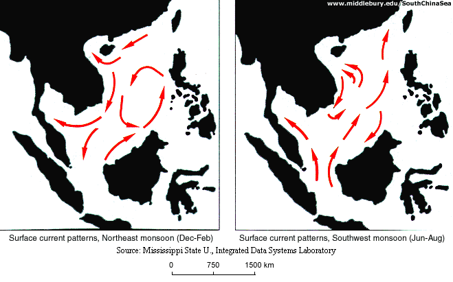
Here's how chaotic things can get in the South China Sea:

monsoons1.gif


FigureEA5.gif


Most of the area being searched has a depth of less than 100 meters - and it's next to a basin that goes down to 1000 m.

Tides in the area are nearly 4 meters, add that to surface swells today of 2.5 meters - that's a lot of water moving around.
 
Didn't it get reported that they can see the plane make a u turn and disappear from satellite . sounds like a system glitch with radar reading
 
Didn't it get reported that they can see the plane make a u turn and disappear from satellite . sounds like a system glitch with radar reading

Geostationary space resources aren't used that way.

That's a job for lower altitude assets and because those are in constant high-speed flight, they have to be scheduled for specific missions at specific times, with a military objective.

There are probably between 6500 and 7000 planes in the air right now and probably better than 70,000 flight arrivals in the past 24 hours.

The Malaysians have reported that it's possible that they made a turn, and they mentioned "military radar," but the only actual data report came from the Chinese and no one believed them -

At the last known position, it changed course from 24
 
... that's a lot of water moving around.

So I saw something about a car that drove off a bridge into roughly 60' of water (~20 meters I think) and the current carried the car nearly 1/2 mile downstream before it hit bottom. That was fresh water which is less buoyant than ocean water, so if the plane went down, based on those pics you posted EM, that could be a huge debris field to search.
 
So I saw something about a car that drove off a bridge into roughly 60' of water (~20 meters I think) and the current carried the car nearly 1/2 mile downstream before it hit bottom. That was fresh water which is less buoyant than ocean water, so if the plane went down, based on those pics you posted EM, that could be a huge debris field to search.

And that's the problem with the constant news reports of:

"mid-air explosion = huge debris field"

"crash on ocean surface = concentrated debris field"


There's no way they can say that after a day in those waters, imo.
 
The MSM can't, under ANY circumstances simply say: "We don't know and will report back as facts come in". It's against the rules. The have to go over every single "what if" condition that may even remotely make sense. That way they can hear themselves talk longer and they may just say something throughout their diatribe that they can look back at and say "see, we reported that". All of 'em are nincompoops. The era of real news reporting died with Cronkite. :(
 
I've been in a major regional FAA operational control center.

Here's how it works, in general:

Controllers are VERY busy dealing with takeoffs and landings for their areas of control.

A LARGE display shows *transponder* signals for everything in their air corridor.

If a flight misbehaves an alarm is shown or sounded - based on the transponder data.

If a plane crosses over properly to another control area, nothing really happens.

Radar is not part of the equation for flights in progress.

That's here.

SPECULATION for there based on few actual reports:


And what it SEEMS like happened here - the transponder went off (no power) at about the time it ought to have transitioned to another control area.

Late night, if there was a control alarm, it may have been missed. Or a systems error may have occurred to suppress the alarm, if any.

So, at some point, someone in Malaysia notices that the flight is no longer on their board, about when it wasn't supposed to be. And someone in Vietnam notices it's not on their board when it should have been. That's what the initial reports seemed very much like.

After that, the panic began.
 
whoops should explain the link sorry about that..a satellite imaging company is launching an effort to crowdsource the search, asking the public for help analyzing high-resolution images for any sign of the missing airliner.
Anyone can click on the link and begin searching the images, tagging anything that looks suspicious. Each pixel on a computer screen represents half a meter on the ocean
 
What I don't get... there are/were 239 passengers on board. They probably all had cellphones, almost all of them as some kind of smartphone. Probably almost all of the smartphones had GPS installed and a good percentage of them had it switched on... wouldn't they all stop transmitting at the same position, at the same time? And wouldn't that information tell us exactly where to look?
 
What I don't get... there are/were 239 passengers on board. They probably all had cellphones, almost all of them as some kind of smartphone. Probably almost all of the smartphones had GPS installed and a good percentage of them had it switched on... wouldn't they all stop transmitting at the same position, at the same time? And wouldn't that information tell us exactly where to look?

That is true I know that dude from Texas had one and think he worked with a computer program firm . I know his android is working .
 
As far as the cell phones, they were over the ocean. Like a lack of radar, I'm sure there was more than likely a lack of cell coverage. So the phones may have known where they were, but wouldn't have been able to transmit that information anywhere.
 
But even with no data transmission, doesn't the coarse GPS triangulation still send a signal?

The phone's transmission anntenna needs to be able to send a string enough signal to reach an antenna compatible with the signal it is sending. More than likely, the devices wouldn't be able to do course location as that is primarily based on tower connectivity.

The fine location (GPS) only has to listen to the Geostationary satellites to calculate a latitude, longitude, and altitude location translated locally to the device as three numbers. The phone would need connectivity to the outside world for this information to go beyond the local device. This is almost certainly information collected in the "black box" with the main difference being the box is designed and engineered to survive a catastrophic event where smart phones aren't. Even the "black box" is unable to transmit this information, and needs to be physically collected and analyzed.
 
Okay, one more daffy question: don't smartphones also use satellite triangulation, in which it doesn't matter how far from land you are?
 
Okay, one more daffy question: don't smartphones also use satellite triangulation, in which it doesn't matter how far from land you are?


Again, without a tower connection, the smartphone would not have any way of reporting its position, and so it wouldn't matter if the phone had it's GPS turned on or not.
 
Okay, one more daffy question: don't smartphones also use satellite triangulation, in which it doesn't matter how far from land you are?

Yes.

Under decent conditions (the cell preloaded with initial data for fast acquisition of GPS signals), a cell phone can locate you with nothing more than GPS.

How it works is simple and yes, it is called triangulation. The GPS birds all share and send a common time signal along with their identity. The cell phone takes time of arrival differences and does some math and bingo - locates you relative to the birds being processed - and translates that to Earth coordinates.

Now - where does that information go when the cell phone has it?

The primary output of your location is your personal screen - usually on a maps app for example.

For most people, it ends right there. Signal comes from sky, gets processed, and goes out the screen as a map display.

For others, the next most common use is - anti-theft.

1 - In some of those cases, some app you've installed periodically networks back to the service provider and says, "jefboyardee's phone is right here at this time." Note that would be a periodic check-in, not a constant data stream.

2 - The more common case is - you contact your phone from your PC and request that it send the current location.

Case 2 is out, no one was on the ground asking while they were in the plane flying.

So - Case 1. How likely? The phones in question would have to be running that specific type of network-aware security app, have GPS turned on, and a network connection (it's possible if the plane featured wifi, many do).

So - conclusion:

A cell would have to 1) be on, 2) have GPS on and a GPS lock (remember, many people don't to save battery), 3) be running a specific type of security app, 4) have had continuous network coverage when that hypothetical app wanted to update "back home," and 5) now comes the big one:

A loved one would have to know about such a thing and have the password.

The odds for all of that are remarkably low.

And - many cell phones are weak GPS receivers and need a sort of "location boost" from local towers to maintain position data.

It's been a while since I've followed GPS trackers for anti-theft. I don't know if the type 1 app still exists. I'm pretty sure that the HTC service for that worked that way, just going by memory though. Plus - I think it checked once an hour until you asked for a specific location. Once an hour would not be good enough in this case.

~~~~~~~

Case 3 - Footprints.

Once upon a time, HTC had a Footprints app. It would make a trace of where you were, great for vacations. They dropped that several years ago.

Once upon a time, Google offered the same thing, collaborating the phone with a Google map on your Gmail account. Then one day, those apps stopped working and Google changed the code and made it impossible for the third party apps doing the same thing.

I don't know if that even exists anymore.

~~~~~~~~~

Never say never, and according to statistics, there's no such thing as being able to predict anything as 100% or 0% possible.

But - I think if you add up the pieces, the probability of anyone running just the right app on just the right hardware and the flight and network conditions allowing it to work and then a loved one knowing just exactly how to access that info - has to be really, really so slim as to be nearly impossible.

So - it's a great question and something to hold out hope for.

But - it's very, very slim.

Again, without a tower connection, the smartphone would not have any way of reporting its position, and so it wouldn't matter if the phone had it's GPS turned on or not.

In town, you can locate fairly well just using towers, no GPS. The iPhone did that before they added GPS. And according to the police TV shows, the carrier can always locate you in a jiffy.

Again, out at sea, no soap.
 
Here's the latest from Reuters -

Malaysia air probe finds scant evidence of attack: sources

It reads with less sensationalism. +1

It sounds authoritative. +1

Some info contradicts from paragraph to paragraph. -1 or more

And all sources are unnamed, just top government dudes. -?

If you're interested, there it is.

Could be the real deal.

Could be more made up media stuff, no telling without named sources pinned at specific times.

~~~~~~~

Interesting but not necessarily reliable -

http://www.cbsnews.com/news/missing...est-experts-to-see-if-missing-plane-exploded/
 
Back
Top Bottom