• After 15+ years, we've made a big change: Android Forums is now Early Bird Club. Learn more here.

Malaysia Airlines tragedies

Ok, I gotcha. :)

I guess my response is that it's not unlikely that when the smoke clears from all this, something is going to change.

An Inmarsat executive was quoted as saying that planes ought to start sending information every 15 minutes.

And the press is consumed with the idea of an active black box.

I'm not sure if your idea is farfetched or right on, to be perfectly honest.

According to the posted video from Inmarsat, what we have started with one engineer asking himself if it was possible if they had any unnoticed data from MH370, days after the flight, days after the search was on in the wrong places.

Things are confused, confusing, and full of speculation now about the right search and what happened.

Imagine where we'd all be if that one guy hadn't asked himself that one question or if he hadn't bothered to check.

Any new solution is going to need to not be so complex and expensive so as to break the bank.

The press that has been so big on the greedy airlines not wanting to spend money on changes and insisting on radical changes (often quoting people whose companies would benefit from the changes) fail to point out the real costs. I saw one estimate for the US alone that would cost $60 to $70 billion. Stack that up worldwide against all of those like Malaysia Airlines who were running in the red financially and the fact that only 60% of the airlines seem to be affording the location subscription services that MH370 did not have.

Seems to me that the radical changes many are insisting upon are a recipe for financial disaster, and your idea might not be.

Critics of Malaysia and Malaysia Airlines are going to whine to the press for a long time. China is having a field day with it.

When the crisis has passed, I think that a lot of people are going to decide that they don't want to be the equivalent of the next Malaysia and Malaysia Airlines, if they haven't already decided that. They might even cover it up by keeping the blame on Malaysia but they will have to be thinking about it.

I'll bet that everything we're all curious about happened in the first hour or ninety minutes of the flight - and the cockpit data recorder only has the last two hours of sound from the cockpit. That's going to include just mechanical noises such as the engines in this case if no one was talking.

Too little data during the flight, data recorders that are too hard to find and then not having all the data when they are.

I agree with you. Rather than ideas that are unsafe or unaffordable, we need some real outside the box thinking to reduce the chances of this happening again.
 
  • Potential debris field spotted by French satellite
  • Malaysia says this is the 'best lead so far'
  • Australian PM cautions against hope of breakthrough
  • Chinese ships join resumed search operation
  • Thunderstorms and poor visibility forecast for search area
  • Malaysia Airlines served with first lawsuit over MH370


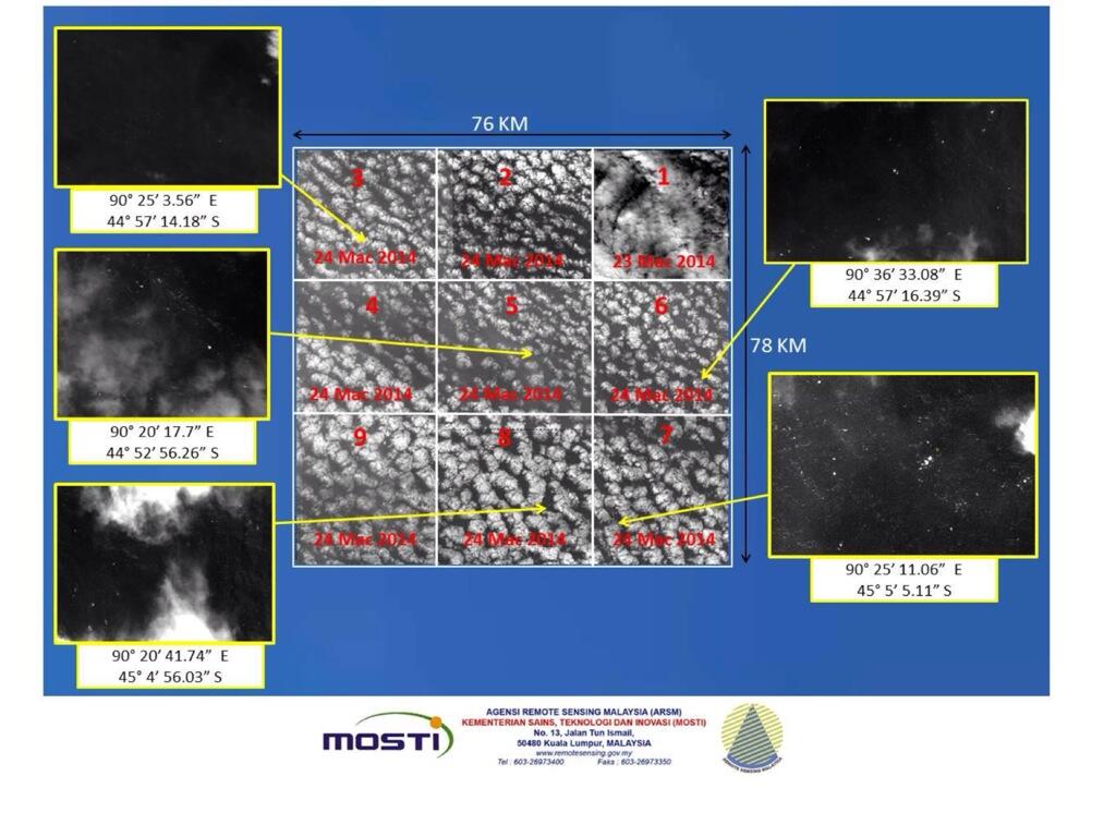
The breaking news is the 122 objects on satellite photos from the 23rd, handed over yesterday, in a 154 square mile area, ranging from 1 to 23 meters long.

MH370: new satellite images show 122 objects in Indian Ocean - live updates | World news | theguardian.com


Edit - ninja'd by Alien Droid!

PS - about the same time, Forbes ran this:

Finding Malaysia Airlines 777 Wreckage Now Highly Unlikely - Forbes
 

Inmarsat says data upgrades would cost airlines $1/hour, asks China to lead for reforms, along with passport checking.

Not sure what he meant by that.

If that's for all planes for 24 hours, that's still only about $615 million per year, worldwide.

No idea if the proposed service could be shut down from the cockpit or not.

Still, sounds like a lot of extra service for not a lot of extra money, if true.

Far cry from tens of billions for an overhaul.
 
Wish we had a better picture of this. Anyway, satellite pictures ...

BjpTq4kCIAENW93.jpg:large


Once again, images are some 3 days old already.
 
TIL about Dr. Robin Beaman, from James Cook University and the project he's a part of to map the sea floor over there.

When I think of the sea floor, I think of images like this -

mid-oceanic-ridge-tectonics.jpg


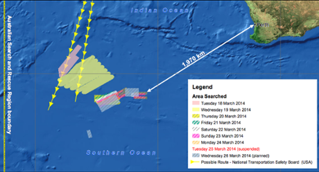
And all along, reports have said that the plane's expected last location is over a plateau there and we've seen it lots in images like this one (repeated for convenience) and it doesn't look so bad and plateau sounds pretty good -

7568251c-5496-4f46-957c-88be26ee4ce4-460x249.png


So, meanwhile, there's this - Search for MH370: Suspected debris lies above undersea volcanoes and it's not great news.

I've lifted some pieces out to give a feel a feel for what the article says -

Robin Beaman, from James Cook University, said so little of the southern Indian Ocean sea floor, including the search zone, had been mapped in detail that any attempt to retrieve wreckage would require extensive 3D mapping, possibly by ships with multibeam echo sounders.

But Australia no longer has the capacity to chart depths of 3000 metres, the average depth of the search area, because the only government vessel capable of conducting mapping of that kind, the RV Southern Surveyor, had been decommissioned in December.

The research vessel's replacement was being built in Singapore and was about to undergo sea trials, Dr Beaman said.

''It's bad timing really. Australia has no capability of mapping these depths,'' he said. Multibeam echo sounders send out sound pulses in the shape of a fan, returning depths of the sea floor directly under the ship and on either side, a pattern known as a swath.

International research groups had conducted sea floor surveys in the region, using multibeam echo sounders to create 3D maps of the sea floor, but the last two surveys occurred almost 20 years ago and used outdated technology, he said.

These surveys charted several areas about 70 kilometres wide while other research ships had gathered detail on the sea floor as they sailed from one port to another, but the paths they charted were only about 10 kilometres to 20 kilometres wide.

''It'll be very unlikely that debris has fallen in those little 10 to 20-kilometre wide zones,'' he said.

''You're left with gaps of hundreds of kilometres where there is no detailed understanding of what the sea floor terrain looks like.''

Add to that the links about how the sea works down there.

In many areas, currents form kilometer-deep vortices where debris and pieces could churn up and down a while and move around rather than just sink.

I still think they're going to find the plane, whenever that may be.

It's just that I started thinking about some of the claims in the press about how this is going to be 1-2-3 deal with the hardest one being locating the wreckage on the surface, then presto-voil
 
You answered my next question which was how can Doppler work if the saterllite is in a geostationary orbit and the target wasn't moving! :)

Here is my best guess at why the doppler effect can be used to determine whether or not the plane flew south and not north:

Satellites in geosynchronous orbit are not in an orbit that is perfectly over the equator. Sometimes it is north of the equator and sometimes it is south. The articles I have read mention a "wobble". I think that this wobble refers to the fact that part of the orbit drifts above the equator and part of the orbit drifts south. I have seen an image depicting a bunch of satellites in orbit around the earth and the geosynchronous ones are in a band around the equator as shown on that diagram. This would indicate that orbits are not perfectly over the equator all the time.

If the satellite is in a position where it is drifting from south of the equator to the north of the equator, then signals from a plane in the northern route would be at a slightly higher frequency than signals from a plane in the southern route. The reason is that it is moving towards a plane in the northern route and away from a plane in the southern route. Based on the satellite pings every hour and assuming that the plane is moving at constant speed, they can determine whether or not a plane is north or south of the satellite.

The frequency of the return signal changes frequency based on their relative speeds. This is how radar guns word. It sends a signal to a car (or any object). If the car is moving towards the gun faster, the return signal that bounces off the car would arrive at a higher frequency than if the car were moving towards the gun more slowly.

So why Doppler when GPS can bypass much of that infrastructure I would have guessed and be more accurate?

GPS on a plane can tell someone who is on the plane looking at the GPS equipment where the plane is. If communications was knocked out, then there would be no way the GPS equipment on the plane can relay the information to anyone else.

Are they avoiding using GPS in some cases, are they avoiding putting their eggs in one basket so to speak and this is about building in some redundancy if GPS saterllites fail?

GPS satellites only transmit a signal that GPS equipment on earth can pick up. Then the GPS equipment (like your phone) calculates where the GPS device is based on the time it took for different GPS signals to reach the GPS equipment. If the signal from a northern GPS satellite arrives sooner than the signal from a more southern GPS satellite, then the GPS equipment knows it is closer to the northern satellite. I believe that GPS equipment needs to receive signals from at least 4 satellites in order to accurately calculate position. There are multiple GPS satellites in orbit and you do have some redundancy if some fail. I'm not sure how many failures would result in some parts of the earth not being able to calculate position.

I can see it says some have GPS, but it seems to me that why not have both just in case. I think they should all have a GPS beacon IMO as 3 minutes using GPS versus maybe an hour using Doppler to work out where something is might make a big difference, not in this case of course!

It all comes down to cost. Every additional piece of equipment you put on the plane to relay information or increase redundancy cost the airlines more. Unless it is mandatory, I highly doubt that airlines will be willing to put in additional equipment. I also highly doubt that any passengers are willing to pay extra (given the choice) to fly on a plane with this extra equipment. Saying a plane will be able to better relay where it crashes is not a really good selling point to passengers.

I assume the Doppler effect being used up to this point to try and find the plane is on a different frequency than the raft equipment!! If it was on the same frequency to what the rafts use then I assume it would have been possible to pin point the plane straight away using these other satellites?

I'm not sure what signalling equipment is available on life rafts.

Shame the ping on the plane couldn't have been remotely adjusted to change its frequency. I'm probably way off base but I'm just thinking out loud and it's been a long day.

I'm not sure what you are getting at here. The ping needs to be set on the frequency that the satellites use to communicate.

Or could the satellites set-up for the raft beacons have been reconfigured to the planes frequency and that would have given much more Doppler ping info!
I'm thinking the Die Hard 2 scenario when they used the ping to talk!! ish!

Please slap me if I'm talking nonsense ;)

:pound:
 
Ok, I gotcha. :)

An Inmarsat executive was quoted as saying that planes ought to start sending information every 15 minutes.
This would be a good and hopefully simple and no cost place to start.

I'm not sure if your idea is farfetched or right on, to be perfectly honest.
I would like to think the latter of course :) maybe I should email Inmarsat and be prepaird to be ridiculed. I have zero knowledge on this industry but I do have an IT background and the amount of data shouldn't be that much from that starting point. But adding all those extra pings/handshakes etc to the existing satellites that were never maybe designed to do this workload might just be way too much.
On the glass half full point of view hopefully it would be a nice simple-ish solution and they can also handle multiple frequencies so it would NOT risk any rescue pings from rafts at sea after a crash etc!

According to the posted video from Inmarsat, what we have started with one engineer asking himself if it was possible if they had any unnoticed data from MH370, days after the flight, days after the search was on in the wrong places.

Imagine where we'd all be if that one guy hadn't asked himself that one question or if he hadn't bothered to check.
He or she deserves a big thanx. Where would things be now.

Any new solution is going to need to not be so complex and expensive so as to break the bank.

Stack that up worldwide against all of those like Malaysia Airlines who were running in the red financially and the fact that only 60% of the airlines seem to be affording the location subscription services that MH370 did not have.
Very good point. This would have made a big difference from the start I assume!

Seems to me that the radical changes many are insisting upon are a recipe for financial disaster, and your idea might not be.
I would be more than happy to think my little idea was a quick simple and cheap upgrade. Most things are never that simple but there's always a first time :) Well I feel fired up on that now so I'm going to do a bit of searching and see what I can come up with.

Critics of Malaysia and Malaysia Airlines are going to whine to the press for a long time. China is having a field day with it.
Well they did make mistakes for sure, we all saw them, I think the worst for me was seeing one of the Chinese relatives being dragged away by 3 men, not a good thing to see at all.
They must have a very open investigation at some point on their handling of it I think, not as a kicking contest but to be a manual on how to and how not to handle such events.

When the crisis has passed, I think that a lot of people are going to decide that they don't want to be the equivalent of the next Malaysia and Malaysia Airlines, if they haven't already decided that. They might even cover it up by keeping the blame on Malaysia but they will have to be thinking about it.
What or who would you blame right now?
Bit early for a blame game right now I know.

- and the cockpit data recorder only has the last two hours of sound from the cockpit.
I did see one someone interviewed but can't remember what news channel that was on. He was saying some planes have black box recorders that record for a very long time! Is there any chance MH370 had one of these?
I can't find any info after a quick search!

I agree with you. Rather than ideas that are unsafe or unaffordable, we need some real outside the box thinking to reduce the chances of this happening again.
I'm all for thinking outside the box ideas. And like you referred to about cost, battery life, safety etc etc that all has to be included in any new tech, and hopefully this will prevent this scenario from unfolding ever again in future.
 
Ok, I gotcha. :)

I guess my response is that it's not unlikely that when the smoke clears from all this, something is going to change.

An Inmarsat executive was quoted as saying that planes ought to start sending information every 15 minutes.

And the press is consumed with the idea of an active black box.

I'm not sure if your idea is farfetched or right on, to be perfectly honest.

It usually takes tragedies like this particular before action is taken. Any change is going to increase costs. Airlines will not do so independently. The regulations have to change in order for airlines to change. I can see there being some changes in regulations to ensure incidents like this are identified more quickly and that action can be taken more quickly.

According to the posted video from Inmarsat, what we have started with one engineer asking himself if it was possible if they had any unnoticed data from MH370, days after the flight, days after the search was on in the wrong places.

Things are confused, confusing, and full of speculation now about the right search and what happened.

Imagine where we'd all be if that one guy hadn't asked himself that one question or if he hadn't bothered to check.

As part of my job, I often analyse log data from IT systems to do troubleshooting. The systems I support generate a lot of data (1 GB every several minutes during busiest times), so it can take some time to identify where the relevant data is first and then analyse it. I can appreciate how difficult it is for this engineer. Most likely, you would be looking at the time it disappeared and not several hours later. I'm glad it dawned on him to look further.

Any new solution is going to need to not be so complex and expensive so as to break the bank.

The press that has been so big on the greedy airlines not wanting to spend money on changes and insisting on radical changes (often quoting people whose companies would benefit from the changes) fail to point out the real costs. I saw one estimate for the US alone that would cost $60 to $70 billion. Stack that up worldwide against all of those like Malaysia Airlines who were running in the red financially and the fact that only 60% of the airlines seem to be affording the location subscription services that MH370 did not have.

Seems to me that the radical changes many are insisting upon are a recipe for financial disaster, and your idea might not be.

Whatever new changes that may be implemented is going to take time to design an implement. There will be a lot of considerations on what changes you make. There will always be pressure to keep costs down.

Critics of Malaysia and Malaysia Airlines are going to whine to the press for a long time. China is having a field day with it.

When the crisis has passed, I think that a lot of people are going to decide that they don't want to be the equivalent of the next Malaysia and Malaysia Airlines, if they haven't already decided that. They might even cover it up by keeping the blame on Malaysia but they will have to be thinking about it.

Or they just take the risk that their next incident won't be one that flies of and ends into a remote ocean. Adding additional equipment to identify and locate a plane in such a disaster is going to cost money. If you don't spend the money, you risk the negative PR that results in a lost plane that becomes extremely difficult to find. I'm sure airlines will do the financial analysis to determine if it is worth it for them to spend the money if they are given the option to do so.

I'll bet that everything we're all curious about happened in the first hour or ninety minutes of the flight - and the cockpit data recorder only has the last two hours of sound from the cockpit. That's going to include just mechanical noises such as the engines in this case if no one was talking.

Too little data during the flight, data recorders that are too hard to find and then not having all the data when they are.

I agree with you. Rather than ideas that are unsafe or unaffordable, we need some real outside the box thinking to reduce the chances of this happening again.

Although the big story now is finding the plane, what is more important is finding out why in the first place. If the root cause of the disaster is something that can be prevented with some changes in regulation, then I feel that money is better spent on preventing future incidents than spending money on locating a plane after another such incident occurs.

If after the investigation is concluded that the root cause cannot be determined due to lack of data, then I can see money being spent on better ways to gather data in preparation of future incidents. If you don't know what happened, you then need to spend money to find out what will happen the next time something like this happens.
 
Here is my best guess at why the doppler effect can be used to determine whether or not the plane flew south and not north:

Satellites in geosynchronous orbit are not in an orbit that is perfectly over the equator. Sometimes it is north of the equator and sometimes it is south. The articles I have read mention a "wobble". I think that this wobble refers to the fact that part of the orbit drifts above the equator and part of the orbit drifts south. I have seen an image depicting a bunch of satellites in orbit around the earth and the geosynchronous ones are in a band around the equator as shown on that diagram. This would indicate that orbits are not perfectly over the equator all the time.

If the satellite is in a position where it is drifting from south of the equator to the north of the equator, then signals from a plane in the northern route would be at a slightly higher frequency than signals from a plane in the southern route. The reason is that it is moving towards a plane in the northern route and away from a plane in the southern route. Based on the satellite pings every hour and assuming that the plane is moving at constant speed, they can determine whether or not a plane is north or south of the satellite.

The frequency of the return signal changes frequency based on their relative speeds. This is how radar guns word. It sends a signal to a car (or any object). If the car is moving towards the gun faster, the return signal that bounces off the car would arrive at a higher frequency than if the car were moving towards the gun more slowly.

QFT, I believe your guess is dead-on correct.

You've just done a better job explaining why Doppler calculations were involved and how they really worked here than all of the popular press articles I've seen put together.

Bravo. :)

Stuff on why the wobble is there, hidden so as not to detract from your central point and explanation but there if anyone wants to look.
The wobble here is probably a figure-8 as shown in this video if true.

We've known about it as a satellite problem for years.

The press will tell you that to get a geosynchronous satellite is simple - and it is.

Go to a certain altitude at a certain speed and the bird will just fly there as if stationary above the ground for a very long time.

But making it geo-stationary, so that the business end is always pointing down to the same place during its daily flight, and dealing with the not-perfectly-round Earth and its very slight wobble opens a whole new set of problems.

Think of the satellite like a pendulum with its string tied to the center of the Earth's gravity above its location.

You tossed it into orbit really carefully with lots of 3D motion factors - you can get close, but you're not going to get perfection. And you get a sort of pendulum effect at the end, creating what appears to be a straight-line or figure-8 wobble.

In the projects I've worked, wobble was a necessary evil to deal with.

This is the first time I've seen it used for good.
 
What or who would you blame right now?
Bit early for a blame game right now I know.

Too soon but I expect my list to be pretty long when this is really all done.

I did see one someone interviewed but can't remember what news channel that was on. He was saying some planes have black box recorders that record for a very long time! Is there any chance MH370 had one of these?
I can't find any info after a quick search!
There are two data recorders - the cockpit voice recorder and the flight data recorder.

Grossi-7.png


The big problem with following the stories is that the press just refers to one, the other, or both together as "the black box."

The flight data recorder is going to contain everything about the flight profile, start to finish, and length of travel time is not going to be a problem.

The cockpit voice recorder in this case is going to be a problem. It only records the last two hours of flight and then it's done, according to all accounts out there.

See also Cockpit voice recorder - Wikipedia, the free encyclopedia
 
Maybe I'm cynical, but I'm not one that subscribes to the belief that no cost is too great to ensure safety. It's cold, but these incidents are very rare. I think as people we refuse to accept that we can't be sheltered 100% from risk. Life is short, sometimes it ends unexpectedly. The sooner we accept that, the easier life will be.
 
The cockpit voice recorder in this case is going to be a problem. It only records the first two hours of flight and then it's done, according to all accounts out there.

See also Cockpit voice recorder - Wikipedia, the free encyclopedia

I heard the two hour part, but that it only kept the last two hours. Your scenario (first two hours) would be more beneficial in this case as to what happened when the flight went radio silent shortly after reaching cruising altitude.:confused:
 
Maybe I'm cynical, but I'm not one that subscribes to the belief that no cost is too great to ensure safety. It's cold, but these incidents are very rare. I think as people we refuse to accept that we can't be sheltered 100% from risk. Life is short, sometimes it ends unexpectedly. The sooner we accept that, the easier life will be.

At the same time, if it's true that around $600 million spread worldwide could have significantly reduced the (yet unknown total) costs of this search, in money, agony, and whatever the political fallout would be, that would be pretty fair in my opinion.

A few days they reported that the US had spent around $2.5 million for the search so far out of a budget of $4 million. I think it's safe to say that before this is over, all the costs together are going to be very high.

Without knowing what happened to cause the problem, we can't even begin to know if it could have been prevented, much less the dollar cost and where we should be spending more besides better location data (and that's only if the assumptions and statements about location and SAR costs are true).
 
I heard the two hour part, but that it only kept the last two hours.

That's absolutely right and I said that in a post yesterday.

Today, I had it backwards - but - I had a good reason for making that mistake.

As soon as I think of it, I'm going to post back. :o

Meanwhile, post edited, good catch, many thanks!
 
The wobble here is probably a figure-8 as shown in this video if true.

The above is what I think the wobble refers to. It makes the most sense. I'm glad you found a link that properly defines what all those other news reports were talking about. I'm rather upset that none of the news reports explained this. It was totally misleading when I first heard them. I felt those media reports did a very disservice. This incident is already confusing already and I think talking about the "wobble" without accurately defining what it means just adds to the confusion.


This is what it sounded like when I first read the various news reports when they talk about the "wobble". It just didn't make sense that the precession of spinning satellites is going to result in the doppler effect being useful in pinpointing the route that the missing plane took.

The press will tell you that to get a geosynchronous satellite is simple - and it is.

Go to a certain altitude at a certain speed and the bird will just fly there as if stationary above the ground for a very long time.

But making it geo-stationary, so that the business end is always pointing down to the same place during its daily flight, and dealing with the not-perfectly-round Earth and its very slight wobble opens a whole new set of problems.

Think of the satellite like a pendulum with its string tied to the center of the Earth's gravity above its location.

You tossed it into orbit really carefully with lots of 3D motion factors - you can get close, but you're not going to get perfection. And you get a sort of pendulum effect at the end, creating what appears to be a straight-line or figure-8 wobble.

In the projects I've worked, wobble was a necessary evil to deal with.

This is the first time I've seen it used for good.

In general, satellites don't have to be in perfect geostationary orbit. Most satellites service a large section of the earth. If the satellite drifts several degrees north or south, it would likely still be able to service the area it is intended to. Services that cover most of the earth except near the poles would have multiple geostationary satellies providing overlapping coverage. Also, radio dishes aimed at satellites don't have to be aimed exactly at the satellite. You can have a small margin of error when aiming at the satellite, so the drift in its orbit will not cause a loss of connection.

Too soon but I expect my list to be pretty long when this is really all done.

There are two data recorders - the cockpit voice recorder and the flight data recorder.

Grossi-7.png


The big problem with following the stories is that the press just refers to one, the other, or both together as "the black box."

The flight data recorder is going to contain everything about the flight profile, start to finish, and length of travel time is not going to be a problem.

The cockpit voice recorder in this case is going to be a problem. It only records the first two hours of flight and then it's done, according to all accounts out there.

See also Cockpit voice recorder - Wikipedia, the free encyclopedia

I remember an interview with some expert on some show years ago that the black box is actually two orange boxes. News programs do often refer to these as the flight data recorder and the cockpit voice recorder. Most of the time, they just call them the black box or black boxes. I guess the alliteration just sounds nicer.
 
I heard the two hour part, but that it only kept the last two hours. Your scenario (first two hours) would be more beneficial in this case as to what happened when the flight went radio silent shortly after reaching cruising altitude.:confused:

The two black boxes record information only until the time that the power gets cut off. I recall some previous crash where the power got cut off before the crash, so investigators were unable to obtain flight recorder information on what happened the moments before the crash. Depending on when the power got cut to the recorders, there may still be some useful information.

At the same time, if it's true that around $600 million spread worldwide could have significantly reduced the (yet unknown total) costs of this search, in money, agony, and whatever the political fallout would be, that would be pretty fair in my opinion.

A few days they reported that the US had spent around $2.5 million for the search so far out of a budget of $4 million. I think it's safe to say that before this is over, all the costs together are going to be very high.

Without knowing what happened to cause the problem, we can't even begin to know if it could have been prevented, much less the dollar cost and where we should be spending more besides better location data (and that's only if the assumptions and statements about location and SAR costs are true).

Additional costs to equipment onboard planes may save on the cost of the rescue and recovery of a crashed plane. This is a very good point. It's just that I'm not sure who ultimately foots the bill for the search, rescue, recovery, salvage and investigation in these crashes. If all airlines ultimately foots the bill, then it would probably be in their interests to spend more on onflight equipment. It would still have to be regulated, but at least then, airlines would offer less resistance.
 
The above is what I think the wobble refers to. It makes the most sense. I'm glad you found a link that properly defines what all those other news reports were talking about. I'm rather upset that none of the news reports explained this. It was totally misleading when I first heard them. I felt those media reports did a very disservice. This incident is already confusing already and I think talking about the "wobble" without accurately defining what it means just adds to the confusion.

Exactly.

This is what it sounded like when I first read the various news reports when they talk about the "wobble". It just didn't make sense that the precession of spinning satellites is going to result in the doppler effect being useful in pinpointing the route that the missing plane took.
While not the same wobble, I gave that to introduce the idea that there are a host of complex motions to deal with and many of them involve pendulum-like motion.

And I was hoping to keep it simple. So, I'm guilty of the same sin as the press. :o :D

Ok - here's the advanced part.

In addition to perfectly circular geosynchronous orbits with 0 degrees inclination with respect to the Earth's axis, communication satellites are often put into slightly elliptical orbits with a slightly inclined angle.

As the bird flies, it follows its ellipse and that ellipse goes above and below the equator.

And what I said about the earth acting as the center point and the satellite acting as a pendulum is still true.

There are idealized models and then there's the reality of flying around Mother Earth - and even in deep space, there's no perfection.

In general, satellites don't have to be in perfect geostationary orbit. Most satellites service a large section of the earth. If the satellite drifts several degrees north or south, it would likely still be able to service the area it is intended to. Services that cover most of the earth except near the poles would have multiple geostationary satellies providing overlapping coverage. Also, radio dishes aimed at satellites don't have to be aimed exactly at the satellite. You can have a small margin of error when aiming at the satellite, so the drift in its orbit will not cause a loss of connection.
And now you can add that to what we've both said and get at least three major factors -

  • satellite stability with respect to itself, going for low wobble in place
  • satellite stability with respect to its intended orbit, going for low wobble from that
  • satellite at an inclined elliptical orbit, appearing to wobble in its ground track

And while that figure-8 looks tempting, remember, the entire period they analyzed took less than 8 hours - or only a third of the figure-8 pattern.


I think before they announced to the world that they were confident, and before they passed a peer review, all of the motion components would have to have been taken into account.

The calculations had to be precise indeed, in my opinion.

And also why it was important to test and pass the analysis against six other 777s in that region before declaring confidence.


No one but Inmarsat and their reviewers really know which factors were major or minor. I can't wait to read the peer-review journals on what they did. :)

All of which goes back to your original statement:
This incident is already confusing already and I think talking about the "wobble" without accurately defining what it means just adds to the confusion.


As for actual drift - too much of that uncorrected for too long and you lose the satellite. But that's just me crossing a T and being a little tangential, not criticizing the point you made, that radio footprints are wide.

And that was my original problem with believing that we'd ever get position based on the signal angle to an antenna array as originally reported:

Radio footprints are wide.
 
Meaning why not launch another plane with the same spec transponders on board and try to recreate the suspected flight path? In that way they will be able to compare the satellite pings data from both planes and maybe understand the difference between both...

They did one better than that.

They took the same ping data from six different Boeing 777 flights, each on separate paths, and created predictions from the analysis.

And then compared that to the actual flight paths for the six planes.

In each case, they were right.

It's one better because it eliminates the need to assume anything (not even the original flight path) except the analysis and it's more trustworthy because they didn't just do it once.

~~~~~~~

By the way, when I was a kid, I tried that trick of recreating the problem with a quarter. I ended up being out 50 cents instead of only 25. I just hope you're happy now.
j/k :rofl:

Srsly though - I lost both quarters. :D
 
:) When I was a kid, I successfully used that trick all the time.
In fact I still use it today.
The coin hardly ever rolls to the exact same place, but the radius to where the coin as stopped is the information needed to locate and establish a precise search zone for the first coin.

WifelyMon creates her own personal chaos field. When we were first dating, I saw her stuff something in her purse and I mentioned that was a bad place for it.

She looked right away, and it wasn't there. I objected. She emptied her purse out on the counter - wasn't there. I examined the empty purse closely. Wasn't there. Her opinion - must not have been important anyway.

Later we met up with another couple and the girls started recounting the story. Again, I objected. She looked at me all flat-eyed and without looking, reached into her purse, pulled it out and said, here, hope you're satisfied, I have my own chaos field.

After dozens of similar incidents I learned two things. First, WifelyMon really does generate her own chaos field.

Second - it's contagious. :D
 
If you drop a coin and lost sight of it, than the best way to recover it is by recreating the scenario and dropping another coin in the same place to observe the trajectory and radius of the second coin. And likely you will be able to understand the possible location of the first coin...

Dropping a coin is one of those experiments that are very sensitive to initial conditions. Depending on the landscape of the surface you drop it on and the distance, multiple coins dropped may end up in different places because the slightest difference in the initial position and orientation of the drop can result in a different final location of the coin. Chaos theory explains this effect.

Meaning why not launch another plane with the same spec transponders on board and try to recreate the suspected flight path? In that way they will be able to compare the satellite pings data from both planes and maybe understand the difference between both...

It is difficult to determine the exact location and heading of the flight in the moments after the transponder stopped transmitting. You would need the information from the flight data recorder for that if in fact the data is there. The satellite pings only show the location of the plane every hour. A lot has happened since the plane disappeared off the radar. The details of the various heading changes and flight altitudes are unknown at this time.

I think there are more practical methods of recreating the flight path than sending another 777 into the air and simulating this. Right now, finding the plane is the best approach at this time. We are pretty confident where the plane went and doing a live simulation is not likely going to provide any additional information other than confirming radar holes over Malaysia and the surrounding countries.

Yesterday I heard on CNN that apparently the plane completely avoided the Indonesian airspace after it went missing.
That alone throws away the theory that the crew or the person in control of the plane was unconscious at the time of the sudden loss of altitude.

Once again I think that there is more to this story than what meets the eye.
And so far I'm under the impression that the investigation seems more interested in scapegoats than answers.

There are still many unknowns at this time. We have to be patient and wait for searchers to find the plane. I think people like to talk and hear about speculation about what happened to the plane. I also heard on CNN that it is speculated that a mini-black hole swallowed up the plane. It's entertaining, but does not really provide any useful or accurate information.

Ok - here's the advanced part.

In addition to perfectly circular geosynchronous orbits with 0 degrees inclination with respect to the Earth's axis, communication satellites are often put into slightly elliptical orbits with a slightly inclined angle.

As the bird flies, it follows its ellipse and that ellipse goes above and below the equator.

If the orbit is inclined with respect to the earth's equator, even a perfectly circular orbit would result the exact position of the satellite wobbling back and forth.

And what I said about the earth acting as the center point and the satellite acting as a pendulum is still true.

I'm pretty sure I understand what you mean. I'll just paraphrase. When viewed from the reference frame of the rotating surface of the earth, the satellite's position will appear to drift back and forth across the earth's surface. This is due to the fact that the satellite's orbit is not perfectly circular and slightly inclined with respect to the equator.

There are idealized models and then there's the reality of flying around Mother Earth - and even in deep space, there's no perfection.

And now you can add that to what we've both said and get at least three major factors -

  • satellite stability with respect to itself, going for low wobble in place
  • satellite stability with respect to its intended orbit, going for low wobble from that
  • satellite at an inclined elliptical orbit, appearing to wobble in its ground track
And while that figure-8 looks tempting, remember, the entire period they analyzed took less than 8 hours - or only a third of the figure-8 pattern.

Perfection is not absolutely necessary when putting satellites in orbit. If you look at the entire solar system, all of the planets' orbits are slightly inclined with respect to each other. None of the orbits are circular (although they are close to being circular). Yet, the planets are all in stable orbit. The same applies to satellites around earch. You don't have to be perfect. You can be off a bit and still have the satellite able to perform its primary function.

What is important for tracking the plane is actually this imperfection in the satellite's orbit. If the satellite were in a perfectly circular orbit that is not inclined to the equator, we would not be able to use it to determine its flight path to a reasonable degree of accuracy because then there would be no difference in the doppler effect between the northern or southern route.

I think before they announced to the world that they were confident, and before they passed a peer review, all of the motion components would have to have been taken into account.

The calculations had to be precise indeed, in my opinion.

And also why it was important to test and pass the analysis against six other 777s in that region before declaring confidence.


No one but Inmarsat and their reviewers really know which factors were major or minor. I can't wait to read the peer-review journals on what they did. :)

I'm very impressed with the people of Inmarsat who were able to deduce the flight path. Once they were able to correctly predict the flight paths of known flights, they were pretty confident they knew the flight path of the missing plane.

As for actual drift - too much of that uncorrected for too long and you lose the satellite. But that's just me crossing a T and being a little tangential, not criticizing the point you made, that radio footprints are wide.

Satellites do have the ability to make a limited number minor corrections to its orbit. I recall a few decades ago, one of the weather satellites failed. They had a backup and over the course of weeks or months, it slowly drifted over to take the place of the failed satellite. The drift of this satellite appears to be within the accepted tollerance for the satellite to perform its primary function.

And that was my original problem with believing that we'd ever get position based on the signal angle to an antenna array as originally reported:

Radio footprints are wide.

Normally, you need at least 2 satellites in order to triangulate its exact position based on information of its direction only. You need 3 in order to triangulate based on information of its distance only. The scientists/engineers had a brilliant idea using the doppler effect which would identify its velocity as well as distance to pinpoint the plane.
 
If the orbit is inclined with respect to the earth's equator, even a perfectly circular orbit would result the exact position of the satellite wobbling back and forth.

I'm pretty sure I understand what you mean. I'll just paraphrase. When viewed from the reference frame of the rotating surface of the earth, the satellite's position will appear to drift back and forth across the earth's surface. This is due to the fact that the satellite's orbit is not perfectly circular and slightly inclined with respect to the equator.

True for the inclined orbit part and almost what I meant in general. Let me try to clarify with some thought experiments. :)

In each case, the center axis of the satellite is fitted with a laser pointer whose objective is to put a dot on the surface of the Earth with no motion on the dot. And because this is a thought experiment, you can magically see that dot if it moves and even see its track as it moved.

Case 1: The satellite has no variation from the equator and its orbit is perfect - but the satellite is wobbling in place around its own axis. Your laser dot will trace something like a figure-8. If only a relatively small piece of time is involved, you'll see a curve traced.

Case 2: The satellite intended orbit has no variation from the equator and it's perfect about its own axis - but it's not perfect in its orbit. Your laser will trace a curve over a small period of time with respect to the period of the error time.

Case 3: The satellite is positioned perfectly and has no orbital error but it's flying at an inclination. Your laser dot will trace something like a figure-8. If only a relatively small piece of time is involved, you'll see a curve traced.

And there are other motion components and that leads to:

Case 4: What is likely is that at least all three cases apply to some extent. The figure you'd see would not fit any simple pattern when viewed on the ground.

Or for viewing the ground trace from the satellite in space of those motions added together. Or for viewing the trace on the airplane position. And bringing it all home - for viewing the frequency of the signals sent from the airplane.

It's tempting to believe that the dominant factor is case 3 because common sense says that the satellite must have moved some greater distances during the time involved. It may be true and it may be that simple.

But - we don't know that.

And neither do we know if the 1/3 portion of the satellite's elliptical path had it somewhat parallel to the plane's path during the time in question. If that happened, then the assumed great travel factor would be very much reduced where the Doppler effect would be concerned. And then at tens of thousands of miles of distance, perhaps the motion from the first two cases would be more important.

And it's not unreasonable that when Inmarsat said wobble they were talking about some sort of generalized version in an effort to explain the complex factors that all hit at once.

And the press isn't even getting to that simplified version. :eek:

Perfection is not absolutely necessary when putting satellites in orbit. If you look at the entire solar system, all of the planets' orbits are slightly inclined with respect to each other. None of the orbits are circular (although they are close to being circular). Yet, the planets are all in stable orbit. The same applies to satellites around earch. You don't have to be perfect. You can be off a bit and still have the satellite able to perform its primary function.
Absolutely correct - you don't need perfection and you're not going to get it. You do need overall stability over time.

What is important for tracking the plane is actually this imperfection in the satellite's orbit. If the satellite were in a perfectly circular orbit that is not inclined to the equator, we would not be able to use it to determine its flight path to a reasonable degree of accuracy because then there would be no difference in the doppler effect between the northern or southern route.
I hate to do this, I really do: probably, maybe, absolutely yes and absolutely no.

Incorrect because that's saying which slice of the figure-8 from an inclined orbit would be more important.

If all we had were the figure-8 from the inclined orbit, circular or elliptical, then there would be some parts of that figure-8 that would be really great for a Doppler analysis with respect to the plane's relative motion and some parts that would be really crappy.

If the imperfection in the satellite's orbit is too great or small, and parallel or not at the same time, we get the same conclusions - great here, crappy there.

:p

I hope it doesn't come across that I'm trying to argue minutia.

What I'm trying to say is, the answer is still an easy concept, but it probably contains several easy parts put together - and that's where the complexity comes in.

I'm very impressed with the people of Inmarsat who were able to deduce the flight path.
Boy, you can say that again!

Satellites do have the ability to make a limited number minor corrections to its orbit. I recall a few decades ago, one of the weather satellites failed. They had a backup and over the course of weeks or months, it slowly drifted over to take the place of the failed satellite. The drift of this satellite appears to be within the accepted tollerance for the satellite to perform its primary function.
Exactly. And it's exactly why we say that satellites are in flight. More precisely, it's controlled flight.

Normally, you need at least 2 satellites in order to triangulate its exact position based on information of its direction only. You need 3 in order to triangulate based on information of its distance only. The scientists/engineers had a brilliant idea using the doppler effect which would identify its velocity as well as distance to pinpoint the plane.
It's really the first of its kind and an outstanding piece of work - brilliant is an excellent description! :)
 
Back
Top Bottom