• After 15+ years, we've made a big change: Android Forums is now Early Bird Club. Learn more here.

Malaysia Airlines tragedies

I'm surprised the PM is calling it game over without recovering any debris or even putting eyes on anything other than a few grainy satellite pictures. He better hope he's right.

The Chinese are reported as insisting that they be allowed to review the satellite ping data and analysis to confirm the British finding.

The Chinese Deputy Foreign Minister there is demanding to know exactly how the Malaysians made the decision.

The US believed it to the point of committing subsurface search resources, the Australians are doing the same, committing the Ocean Shield, capable of black box searching.

http://en.wikipedia.org/wiki/ADV_Ocean_Shield

The basis for the decision is clearly another first in aviation history.

MH370 has been filled with them. :(

PS - in a reply to the Chinese complaint that the satellite finding took so long, Hishammuddin said: "Can I also remind you that we received satellite data from China involving 'sightings' in the South China Sea, which made us detract ourselves from the search and rescue to search areas we already searched, and it was found to be negative."
 
PS - in a reply to the Chinese complaint that the satellite finding took so long, Hishammuddin said: "Can I also remind you that we received satellite data from China involving 'sightings' in the South China Sea, which made us detract ourselves from the search and rescue to search areas we already searched, and it was found to be negative."
He looked mega peed off when he was asked a question that he gave that response to!
Bit unfair response perhaps as those items may have sunk soon after photo being taken!

Apparently there is a another ping/hand-shake or at least a partial one, the UK Satellite company I believe is going to test why the very last ping data is not complete. This might help establish if this happens when the plane ran out of fuel and power was lost etc!
If they can make sense of that the expert being asked questions on the news was saying this could help reduce the search area even further.

Some questions I didn't hear asked or talked about;
When a raft is deployed from the plane, how many can it hold and how long do provisions last?

Do the rafts have a satellite phone or some sort of beacon installed?

I'm surprised about the announcement that they must all be dead considering no plane bits have been found, all that stuff so far could just be other junk that was already there like apparantly the 10,000 shipping containers floating the 7 seas!!
Keeping in mind also there have been a few people and one very recently who survived for around a year lost at sea on a small boat! Not many can do it, but it for me underlines you don't give up until you have searched your nuts off.

One last thing. Who reviews the Tomnod maps? I found a couple of things that might have been plane debris, but there is no notification that anyone has looked at my map pins! I know there is a spot where it will tell you if someone agrees with your points, but nothing to show they were checked and to assure you it wasn't all a waste of time!
 
Do the rafts have a satellite phone or some sort of beacon installed?

Each of the 8 inflatable ramps are equipped with an ELT - emergency locator transmitter - that sends a signal to satellites.

The ones on this plane could have been made by Honeywell or Artex.

Here's how Artex says it works -

http://www.acrartex.com/landing/search-and-rescue/

TIL that those are using the Doppler effect to get location too -

The satellites relay the 406 MHz emergency message to a ground station called the Local User Terminal (LUT). The LUT calculates the location of the signal by measuring the Doppler shift caused by the relative movement between the satellite and the beacon and forwards the location to the Mission Control Center (MCC).

In this case, several lower orbit satellites are used to determine location.
 
Unless the pilot successfully ditched the plane into the ocean, I don't think anyone would be left to use the life rafts.
 
Do the rafts have a satellite phone or some sort of beacon installed?

If a raft was deployed and it was a float with the current of the seas or ocean wouldn't this either over turn or deflated with the passengers just either drowning or hope someone can help out . I still say this craft is sitting on land some where .
 
Unless the pilot successfully ditched the plane into the ocean, I don't think anyone would be left to use the life rafts.

I was more hopeful when it could have been the South China Sea on a lucky stretch of calm.

Hitting the water at the wrong angle at about 75 mph or above is a lot like hitting concrete. Turbulent seas with large waves and swells make just about everything the wrong angle, pilot or no pilot.

I don't have an opinion on the odds.

I do have an opinion that someone will find the plane even if SAR doesn't.

They found the Titanic, they found the Bismarck, and they even found Gus Grissom's Mercury capsule.

I hope it's SAR but either way, I think that someone is going to find it.
 
Insightful information on the Southern Ocean -

Why locating MH370 in the Southern Ocean is so difficult

I was going to pull an excerpt or two but that wouldn't do it justice, so instead, I'll simply recommend checking it out.

By Erik van Seville, Research Fellow and Lecturer in oceanography at University of New South Wales.

Pretty much the reason why it is difficult to find any debris is the same reason why you cannot get any reasonable weather forecast beyond a few days to a week. Ocean (and air) currents are chaotic systems (as defined by chaos theory). They are extremely sensitive to initial conditions. The article describes an expedition where they
deployed ten pairs of satellite-tracked drifting buoys into the ocean, at exactly the same moment and with only 10m spacing.
These drifted far apart after a few days. It has a great image of how any debris from the plane could have potentially spread across an area of the ocean larger than Australia.

It's been over 2 weeks since the plane disappeared. If in fact the debris could have spread hundreds or thousands of kilometers from the impact site, I would think that the information from the satellite ping would provide a better estimate of the location of the plane than any debris. I think that the search for debris this late would be to confirm that the plane had crashed rather than to really locate where the wreckage would be.

The search has been called off yesterday due to weather conditions. If weather conditions are that severe, I would think that it would be severe enough to move any debris even farther from the crash site.

Here's a link with a video of how they are able to use the satellite data to determine the flight path of the plane: How 'groundbreaking' number crunching found path of Flight 370 - CNN.com

This has never been done before, so they had to come up with a method for locating the plane. Once they came up with the method, they tested the method on known flights to see how accurate they can be. They were able to successfully determine the location and direction of existing known flights with a reasonable amount of accuracy and are able to give a location of the possible crash site within that range of accuracy. It took a long time and I commend the scientists and/or engineers who are able to come up with this method for determining the location of the missing flight.
 
Press conference, about 11 hours ago.


International working group to look at the data and attempt further refinements on where the plane went down and perhaps refine the search area.
 
7568251c-5496-4f46-957c-88be26ee4ce4-460x249.png


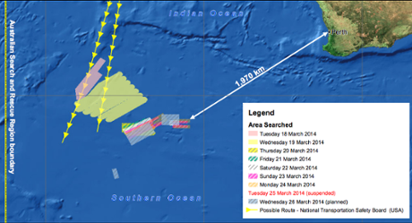
Two ships and twelve aircraft (7 military, 5 civilian) looking in 3 areas today.

A total of six countries are now assisting in the search and recovery operation
 
Each of the 8 inflatable ramps are equipped with an ELT - emergency locator transmitter - that sends a signal to satellites.

The ones on this plane could have been made by Honeywell or Artex.

Here's how Artex says it works -

The Search and Rescue Process | ACR ARTEX

TIL that those are using the Doppler effect to get location too -


In this case, several lower orbit satellites are used to determine location.
You answered my next question which was how can Doppler work if the saterllite is in a geostationary orbit and the target wasn't moving! :)

So why Doppler when GPS can bypass much of that infrastructure I would have guessed and be more accurate?
Are they avoiding using GPS in some cases, are they avoiding putting their eggs in one basket so to speak and this is about building in some redundancy if GPS saterllites fail?
I can see it says some have GPS, but it seems to me that why not have both just in case. I think they should all have a GPS beacon IMO as 3 minutes using GPS versus maybe an hour using Doppler to work out where something is might make a big difference, not in this case of course!

I assume the Doppler effect being used up to this point to try and find the plane is on a different frequency than the raft equipment!! If it was on the same frequency to what the rafts use then I assume it would have been possible to pin point the plane straight away using these other satellites?

Shame the ping on the plane couldn't have been remotely adjusted to change its frequency. I'm probably way off base but I'm just thinking out loud and it's been a long day.
Or could the satellites set-up for the raft beacons have been reconfigured to the planes frequency and that would have given much more Doppler ping info!
I'm thinking the Die Hard 2 scenario when they used the ping to talk!! ish!

Please slap me if I'm talking nonsense ;)
 
Unless the pilot successfully ditched the plane into the ocean, I don't think anyone would be left to use the life rafts.
I did see some documentory a while ago, it showed a very bad crash, aircraft rolled, one wing ripped off. many died but I think about 56 survived. It was just off the coast and holiday makers went to the rescue.
So based on seeing that some could have survived if it didn't nose dive I think.
 
If a raft was deployed and it was a float with the current of the seas or ocean wouldn't this either over turn or deflated with the passengers just either drowning or hope someone can help out . I still say this craft is sitting on land some where .
I hope you're right, would be great if all this was wrong and they are safe and well.
I've see self-righting rafts but not sure how long they stay afloat. they really need to be the sort that can't turn over, but if they are the covered type I and I would think they must be then hopefully they would come upright while full of people! not much good if they don't!
 
You answered my next question which was how can Doppler work if the saterllite is in a geostationary orbit and the target wasn't moving! :)

So why Doppler when GPS can bypass much of that infrastructure I would have guessed and be more accurate?
Are they avoiding using GPS in some cases, are they avoiding putting their eggs in one basket so to speak and this is about building in some redundancy if GPS saterllites fail?
I can see it says some have GPS, but it seems to me that why not have both just in case. I think they should all have a GPS beacon IMO as 3 minutes using GPS versus maybe an hour using Doppler to work out where something is might make a big difference, not in this case of course!

I assume the Doppler effect being used up to this point to try and find the plane is on a different frequency than the raft equipment!! If it was on the same frequency to what the rafts use then I assume it would have been possible to pin point the plane straight away using these other satellites?

Shame the ping on the plane couldn't have been remotely adjusted to change its frequency. I'm probably way off base but I'm just thinking out loud and it's been a long day.
Or could the satellites set-up for the raft beacons have been reconfigured to the planes frequency and that would have given much more Doppler ping info!
I'm thinking the Die Hard 2 scenario when they used the ping to talk!! ish!

Please slap me if I'm talking nonsense ;)

GPS on a raft - far more complex, far more power consumption.

Might not acquire a GPS signal. Needs calibration. Needs to pick up ephemeris tables from satellites before location service can begin.

Will not send position to GPS satellites.

Needs a more complex signal going to other satellites. More processing, more power drain.

And cost more, up front and for maintenance.

All to accomplish what a simpler, more power-efficient system already does.

You can't send GPS coordinates for three minutes to trade off an hour's signal.

Rafts move.

See my posts about the sea conditions - this isn't the Hudson.
 
I don't understand why the locator signal on the "black box" is so weak. They should redesign that with an ultra low frequency signal that can travel long distances. Also, I'm sure they can improve on the battery life. Making these flight data recorders easier to locate should be the priority if any reforms come out of this fiasco.
 
I don't understand why the locator signal on the "black box" is so weak. They should redesign that with an ultra low frequency signal that can travel long distances. Also, I'm sure they can improve on the battery life. Making these flight data recorders easier to locate should be the priority if any reforms come out of this fiasco.

Stronger signal, higher power consumption. All things equal, the signal won't last as long.

Maybe they'll improve.

Lower frequency does travel much further underwater.

It also increases the difficulty of pinpointing location.

Both reasons are exactly why we use them on subs.

Plus - lower frequency means more antenna complexity.
 
GPS on a raft - far more complex, far more power consumption.

Rafts move.

See my posts about the sea conditions - this isn't the Hudson.
I was referring to what you said previously
In this case, several lower orbit satellites are used to determine location.
I'm well aware that rafts move lol and goes without saying what the ocean is like down there.
Of course with enough satellite coverage the raft could be at full stop and still be tracked down.
 
I was referring to what you said previously I'm well aware that rafts move lol and goes without saying what the ocean is like down there.
Of course with enough satellite coverage the raft could be at full stop and still be tracked down.

Ok I guess I didn't understand the question lol, sorry. :)
 
Ok I guess I didn't understand the question lol, sorry. :)
No probs :D I don't always make myself very clear and not had much sleep recently either.
I know it's not very relevant now anyway, but I would be interested to know what you think if my idea of switching satellite that are used to pick up life rafts could have been used to hunt for the plane, frequency change or if possible add an additional frequency for a short time while the plane was still flying?

I know very unlikely that all that would have or could have been done even if possible, but if there is a possibility for this to work in theory then maybe it could be a very remote backup option in future!
I know it's probable the equipments is totally different, frequency can't be changed etc but I was just trying to think outside the box, perhaps too far!
 
Back
Top Bottom