• After 15+ years, we've made a big change: Android Forums is now Early Bird Club. Learn more here.

Malaysia Airlines tragedies

From http://www.nytimes.com/2014/03/27/world/asia/missing-malaysia-airlines-flight-370.html

wind_waves_710px_V4.gif


Time lapse from March 9th through the 23rd.

Wind on the left, waves on the right - whiter on the left means higher wind speeds, whiter on the right means higher waves, solid white is land.

The square box is the search area.
 
There are two flight paths projected south by the NTSB, both lead to the present search area and that's been confirmed by the aircraft's signal analysis.

One of those paths assumes that the last position before turning south was at the northern end of the Malacca Straight.

Turning from that point and time, flying over Indonesia would not have happened.

The second projected flight path assumes that because the radar data was never confirmed to be MH370, it didn't go to the Malacca Straight, it turned earlier and flew over Indonesia.

I don't understand the problem you're having.

No one knows if they flew over Indonesia or not.

And I would definitely question the credibility of any news organization that hasn't made the above points clear to you.

In each map of the search area I've posted all week from the Australian government, there are two yellow lines showing the two probable flight paths.

And the satellite analysis has an error band wide enough to encompass either one by the time of the last signal.

Regardless of what you choose to believe about who turned where or why, it sounds like you're giving more credit to the Gong Show from CNN than to the Math Show at Inmarsat and the NTSB.

Which is fine, that's your right - I just don't get the problem with whether it flew over Indonesia or not.

Won't change the fact that the plane went down somewhere around the the transition between the Indian and the Southern Ocean.

Btw - if the Indonesians found later that they missed the flight in real time on radar, same as many claim that the Malaysians and Thai did, do you think that they would say so? That the Indonesians aren't as incompetent as the rest of them?
 
@EarlyMon
Sorry if my writing is that hard to understand.
Selective reading syndrome can also be a factor.
I understand completely. :)

Still not sure why you have an issue with avoiding Indonesian airspace.

Could someone have done that on purpose?

Sure, why not. No one knows what happened up there regarding cause.

As for hypothesis, I agree completely and that's the right word.

Given that the radar was never conclusively tied to MH370, unlike the aircraft responses to satellite pings, it's pure hypothesis if that data represents what the plane did.

Exactly why there were two hypothetical paths south, prior to the satellite data findings.
 
Fair enough, nothing we know can refute those facts or theories.

We could debate nuances - rapid descent is also part of decompression procedure for example - or how the nuances add up.

We might agree or disagree and that's fine too - I just hate the stories that claim that they know anything in those regards or claim better odds for any point of view, whether accident, hijacking or criminal act.

And my reason for hating those reports is really simple.


I don't think that any of the agencies involved really knows enough and I don't believe that they've all told us all that they do know.

So reporters with their certainties or odds and secret sources can stuff it as far as I'm concerned.

If any of us do it, or if they put it in the editorial section with OPINION at the top, that's fine.

But reports claiming most of the theories and opinions as facts are just irresponsible in my opinion, and I find it disgusting.


I look at those handling the data or being interviewed after searching and I tend to find more honesty. A lot more use of words like might and maybe.


As to why it ended up going south?

I have no idea, but the present data is more highly compelling than any other that it did.

I can actually imagine very good reasons for the plane turning south, for both an accident or criminal scenarios.

And no matter how I present them, they ought not be published as facts or highly probable.
 
:confused:Sorry, If you missed my point completely.

Although CNN broadcasted some nonsense before, that don't mean that the News Channel lost is credibility completely.
Here some links from the region in relation to confirm the news.
Govt insists MH370 did not fly into Indonesian airspace | The Jakarta Post

Indonesian military radar did not detect missing airplane - ANTARA News

And if the Indonesian Army claims that the plane didn't enter their airspace. Than is very likely it didn't.

Sorry, if I misunderstood your post. There is definitely a lack of information regarding what happened to the plane. The satellite pings only give the approximate location of the plane every hour. There has been a lot of conflicting information regarding what happened after radar contact was lost when the transponder stopped transmitting.

▪ Looking for a needle in the haystack...

The direction of this topic and the general media news at the moment is that the Aircraft crashed in the South Indian Ocean.
But not one single piece of evidence is available to that.

:(Is pointless to deploy fancy submarines and fancy sonar equipment on the location when there is still no debris found and confirmed to be from this craft.

Talking about debris:
(To that point you can look into the middle of the Pacific Ocean and you will find one or more than one archipelago of isles made of garbage and plastic bags.)
None of the above from the airplane in question.

▪ We need to find the haystack first!

e8u5yjar.jpg


Looking for missing Flight 370, the ‘needle in a haystack’

I'm surely interested in the possible flight path or paths taken.
If the airplane really flew South?
Than it looks like it avoided the Indonesian airspace completely.
And no autopilot will make that decision on is own. Unless if is aware of the geographic political troubles in the region...!?!
That points to someone to be conscient at the controls of the plane at the time after the sudden loss of altitude.
;) well unless if the autopilot is Kit from nightrider or something like that. lol "Now that is something really hard to believe in".

There are still many questions regarding what happened shortly after the time when the transponder stopped transmitting. We simply don't have enough information right now to determine what caused the plane to be lost. With so much time since the disappearance, any debris from the plane to be found may possibly wash ashore somewhere rather than being found in the ocean. Even if you do find debris in the ocean, it could be nowhere near the crash site where the majority of the wreckage or recorders will be.

I think that the satellite pings provide the best lead to where the recorders are. I don't think any debris would give a better indication where the recorders may be. The recorders only have less than 2 weeks of power left. I think it would be worthwhile to start looking for them now. Even if you cannot recover them, at least locating them would be easier now than after their transponder signal is dead.
 
No results for the latest search, called off on account of bad weather.

Reports of turbulence and icing - and one report claiming that planes got in two hours but without visibility. Planes ordered back according to a number of accounts.

It seems according to reports that ships are still searching - but honestly, I doubt it. I expect if weather is bad then they're just trying to keep on station until they can look again, too.

Sadly, I couldn't find a single, straightforward weather report without additional statements that the plane was tracked on radar, flew here and there, relatives are pissed, the crash may have been caused by XYZ and other nonsense.

Despite headlines promising to tell me how the search really went and then what the weather really was and what might be planned for tomorrow - I got nothing.

Evidently, a weather and SAR status report, without the extras, is just too much to ask for. :mad:
 
And you may have heard about the ADV Ocean Shield.

Nearly every news outlet out there right now is saying that that's the bad boy that's going to tow the TPL-25 and go black box hunting.

140324-N-ZZ999-002-1500-660x495.jpg


To those in the press claiming that, here's your award.

funny-jackass-donkey-grinning-ass-goofy-animal-picture.jpg


You may have also heard about the Ocean Shield because a few days ago I mentioned that that is also equipped to hunt for black boxes and would be a second resource, in addition to the TPL-25.

Who's right? Who can you believe?

Well - the TPL-25 belongs to the US Navy.

And they seem to be firmly convinced that it's going to be towed by Seahorse Standard — currently under contract by the Royal Australian Navy.

U.S. Navy Sends Underwater Sonar Robot in Search for Missing Malaysian Airliner | USNI News

And a special mention to Wired - they were one of the few who got this right.

One expert said that he had inside information that these are really two names for the same ship.

Using a detailed investigative analysis involving image search heuristics, I was able to uncover shocking evidence.

Here's the Seahorse Standard -

Seahorse-Standard-873163.jpg


Here's the Ocean Shield -

OceanShield_large.jpg


I was able to get ahold of one of our special consultants and he confirmed that those appear to be two entirely different ships. He even went on to say, "I don't think that those are the same."

However, unnamed sources close to the investigation claimed that the first picture is the Easter Bunny and the second is really an choo-choo train. For obvious reasons, I promised to protect their anonymity.
 
the sudden loss of altitude smells more of a radar avoiding maneuver on a confusing airspace border than a accidental tragedy itself.

A rapid descent from FL45 to FL23 isn't going to avoid any ground-based tracking. Over blue water you need to be skimming the waves below 500ft AGL to evade modern EWR systems, and that's in a small low-reflectivity fighter.
 
BBC News - Flight MH370: Thai satellite 'shows 300 floating objects'
A Thai satellite has detected some 300 objects in an area of the southern Indian Ocean being searched for missing Malaysia Airlines flight MH370.


The images were taken by the Thaichote satellite on 24 March, a day after images from a French satellite purported to show 122 floating objects. [...] and were said to show some 300 floating objects scattered over an area about 2,700km (1,680 miles) south-west of Perth. The objects were about 200km (120 miles) from the site of the French satellite images.
Eleven planes were sent out again on Thursday.

However, Amsa later tweeted: "Update: Ships staying in search area & will attempt to continue searching but all planes returning. Bad weather expected for next 24 hours."

Amsa spokesman Sam Cardwell said eight of the 11 planes had reached the search zone and looked for about two hours before the suspension. He said: "They got a bit of time in, but it was not useful because there was no visibility."

Lt Cmdr Adam Schantz, in charge of the US Navy's Poseidon P8 plane, said: "The forecast in the area was calling for severe icing, severe turbulence and near-zero visibility. Anybody who's out there is coming home and all additional sorties from here are cancelled."
 
Interesting. As opposed to nations renting time on Digital Globe's Worldview-2, the Thaichote belongs to Thailand and was their first bird for Earth observation.

It's flying in a sun-synchronous retrograde orbit at 98.7
 
Apparently there is a another ping/hand-shake or at least a partial one, the UK Satellite company I believe is going to test why the very last ping data is not complete. This might help establish if this happens when the plane ran out of fuel and power was lost etc!
If they can make sense of that the expert being asked questions on the news was saying this could help reduce the search area even further.

This has been bugging me ever since you brought it up and I finally found it.


Curious about what else David Soucie had to say, I also found this from yesterday.


From his own bio -

David Soucie is the author of
 
Meanwhile, Japan is also providing satellite photos with 10 objects in the search area.

Unlike the Thai ones taken Monday and provided Wednesday, reports say the Japanese took their photos on Wednesday, found the objects, provided the info to the Malaysians and got into the press - all on the same day.

Japan said it provided Malaysia with information from satellite images taken Wednesday showing about 10 objects that might be debris from the plane, with the largest measuring about 4 meters by 8 meters (13 feet by 26 feet). The objects were located about 2,500 kilometers (1,560 miles) southwest of Perth, Japan's Cabinet Intelligence and Research Office said.

Jet Search Cut Short; New Satellite Spots Objects - ABC News
 
Width of Malacca Straight: 40 miles.

Horizon point of typical air defense radar at typical 100 feet elevation - 12.24 miles.

d(in km) = 3.57 * sqrt(height, in meters)

Effective range of that same radar - more than double that.

Except for the fact that waves create a radar signal scattering effect, and that radar has trouble with returns given clutter, coastal radar ought to have been able to see down to about sea level plus that factor - or - down to about 500 feet or less, about halfway in to the Straight.

Place the radar further inland and (insanely) lower its elevation (for purposes of argument) and the lower floor rises.

But not to the many thousands of feet that the airplane was at when lost.

And again - it might have been MH370, it might not. The data could not say.

My personal conclusion - the radar data are insufficient to draw any one conclusion.

Facts had the radar data been trustworthy - 1) we'd have known if it was MH370, 2) we'd have a very good estimate if the attempt was for avoidance or not.

Fill in the missing dots on the radar tracks however you choose.

PS - I can post the link (if asked, it's for operations in Asia and I've got it somewhere in my history) that says commercial aircraft primary radar doesn't bother above 25,000 - because they care about anything below that, expecting it to be on approach or takeoff.

But - they won't cover everywhere, just within a reasonable range of their airports.

I don't know if that's useful, but fwiw, there's that too.

All of the above is assuming working systems and competent operators.
 
Search for Missing Plane Moving Nearly 700 Miles, Based on Radar Analysis

The authority said it was acting after further analysis of radar data from when the plane turned over the South China Sea and flew back over Peninsular Malaysia showed that the aircraft was moving faster than previously estimated and so would have used more fuel.
I can't wait to hear the storm on this one.

The questions that raises are obvious.

In any case, that's a little more than an hour's worth of flight at normal speed and about an hour and half or so back from the original speed estimate.

Remember, the NTSB and satellite ping tracks were specified with an hour's margin of error.

Plus the difference in drift estimates now.

~~~~~~

First question it raised for me was this, saw it yesterday -

Malaysia says there's sealed evidence on MH370 that cannot be made public

~~~~~~

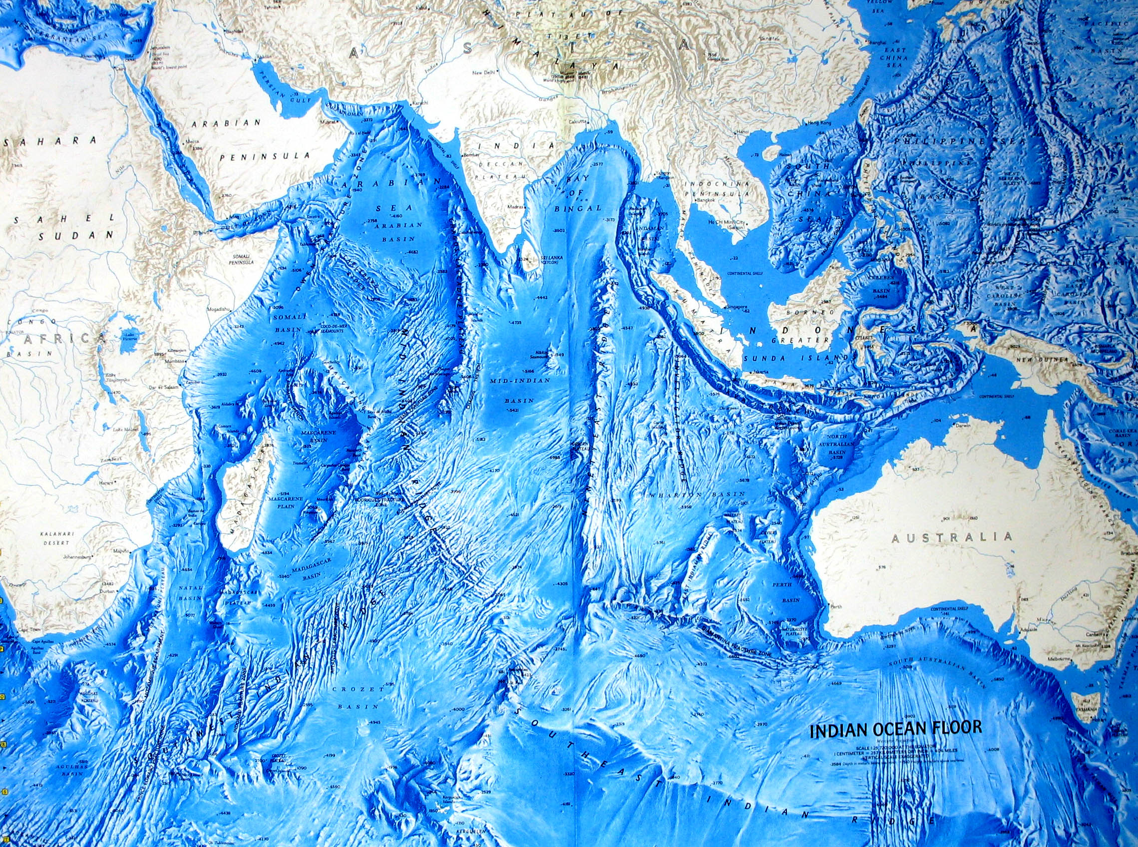
If true, then a floor search might go up to the Broken Ridge.

Bad as things looked before, that looks worse.

indian.gif


More detail of same:

indian-ocean.jpg
 
Now it's getting spicy...

Yes right?

I couldn't believe the headline when I saw it.

Then when I read that Malaysia was officially saying this to the families in China, I was nearly astonished -

The sealed evidence included air traffic control radio transcript, radar data and airport security recordings.

I wonder how much of today's breaking story is owed to the Singapore press just doing their job yesterday?

Maybe nothing but it really makes me wonder.
 
Rather than going through press snippets, here's what the AMSA statement in PDF says:

28th March, 2014: 12.30pm (AEDT)
Search operation for Malaysia Airlines aircraft: Update 23
The search area for missing Malaysia Airlines flight MH370 has been updated after a new credible lead was provided to the Australian Maritime Safety Authority (AMSA).
As a result today’s search will shift to an area 1,100 kilometres to the north east based on updated advice provided by the international investigation team in Malaysia.

The Australian Transport Safety Bureau (ATSB), Australia’s investigation agency, has examined this advice and determined that this is the most credible lead to where debris may be located.

The new search area is approximately 319,000 square kilometres and around 1,850 kilometres west of Perth.

The new information is based on continuing analysis of radar data between the South China Sea and the Strait of Malacca before radar contact was lost.

It indicated that the aircraft was travelling faster than previously estimated, resulting in increased fuel usage and reducing the possible distance the aircraft travelled south into the Indian Ocean.

ATSB advises the potential flight path may be the subject of further refinement as the international investigative team supporting the search continues their analysis.
The Australian Geospatial-Intelligence Organisation is re-tasking satellites to image the new area. Weather conditions have improved in the area and ten aircraft are tasked for today’s search.

They include two Royal Australian Air Force (RAAF) P3 Orions, a Japanese Coast Guard jet, a Japanese P3 Orion, a Republic of Korea P3 Orion, a Republic of Korea C130 Hercules, a Royal New Zealand Air Force (RNZAF) P3 Orion, a Chinese military Ilyushin IL-76, a United States Navy P8 Poseidon aircraft, and one civil jet acting as a communications relay.

A further RAAF P3 Orion has been placed on standby at Pearce to investigate any reported sightings.

There are now six vessels relocating to the new search area including HMAS Success and five Chinese ships.

AMSA and the ATSB will hold a press conference at 1430 (AEDT) to provide more details on the new search area.
A short video of the statement is at the Sydney Morning Herald site.

And just in again from the AMSA (PDF) -

28th March, 2014: 1430 (AEDT)
Search operation for Malaysia Airlines aircraft: Update 24
Australian Maritime Safety Authority Emergency Response General Manager John Young.
Australian Transport Safety Bureau Chief Commissioner Martin Dolan.

We would like to update you on some credible information AMSA has received from the ATSB which will see the search area refocused today.

The AMSA search for any sign of the missing Malaysia Airlines flight MH370 has been shifted to an area north following advice from the Australian Transport Safety Bureau.

An international air crash investigation team in Malaysia provided updated advice to the ATSB, which has examined the information and determined an area 1100 kilometres to the north east of the existing search area is now the most credible lead as to where debris may be located.
The new search area is approximately 319,000 square kilometres, about 1850 kilometres west of Perth.

The Australian Geospatial-Intelligence Organisation (AGO) is re-tasking satellites to capture images of the new area.

Weather conditions are better in the revised area and ten aircraft have been tasked for today’s search.

They include two Royal Australian Air Force (RAAF) P3 Orions, a Japanese Coast Guard Gulfstream 5 jet, a Japanese P3 Orion, a Republic of Korea P3 Orion, a Republic of Korea C130 Hercules, a Royal New Zealand Air Force (RNZAF) P3 Orion, a Chinese People’s Liberation Army Air Force Ilyushin IL-76, a United States Navy P8 Poseidon aircraft, and one civil Australian jet acting as a communications relay.

Four of the ten aircraft are overhead the search area, with a further six planes to fly over the area today.

A further RAAF P3 Orion has been placed on standby at RAAF Base Pearce in WA to investigate any reported sightings.

Six ships are relocating to the new search area including HMAS Success and five Chinese ships.
Chinese Maritime Safety Administration (MSA) patrol ship, Haixun 01, is in the search area.
HMAS Success is expected to arrive in the search area late tomorrow night.

A US towed pinger locator and Bluefin-21 Autonomous Underwater Vehicle have arrived in Perth to assist with location and recovery of the black box.

The depth of the water in the search area is between 2000 and 4000 metres.
 
Here's the full text of the opening statement to today's media briefing by Malaysia's acting transport minister Hishammuddin Hussein:
Introductory statement

Today, the search for MH370 has been further refined. The international investigation team continue working to narrow the search area, and shed further light on MH370
 
This has been bugging me ever since you brought it up and I finally found it.


Curious about what else David Soucie had to say, I also found this from yesterday.


From his own bio -


Hmmmmm.

According to the second video from 1:43 to 1:52, sidescan sonar won't work, they'll need to go look - visually. Oooookay.
Sorry not much time to be online so a late reply.
Cheers for that.
The Youtube account apparently has been deleted for the first vid !! spooky..
That comment on battery storage is very worrying and will be a big big mistake if they were stored above their maximum temperature.
If the ping has stopped it might take a very long time to find that plane.

While I think of it, what temperature can the lithium batteries that were in storage handle. I've missed a lot of posts so sorry if this has already been covered!
I found this and makes for some interesting reading.
BBC News - Batteries on planes pose 'increased fire risk'
Lithium-ion battery - Wikipedia, the free encyclopedia
Boeing 787 Dreamliner battery problems - Wikipedia, the free encyclopedia

Why the heck will sidescan sonar not work then? I didn't anything on this yet. I'm behind the curve you could say!
 
Back
Top Bottom